PILOT SITES
Past work and issues faced by the site
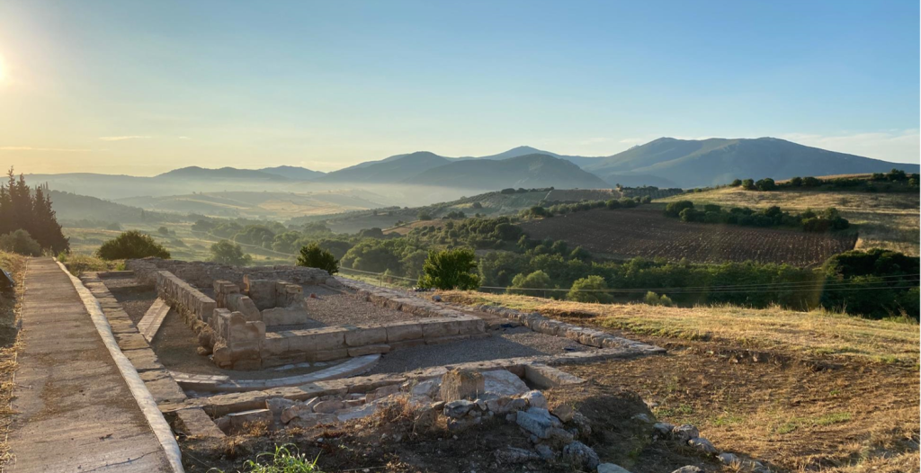
From 2018, the southern temple complex has been restored by DAI. In 2021, a hydrological study for the management of rainwater was conducted where materials and their behaviour during yearly climate variations, was analysed. Phenomena of frost pose a constant danger to the site’s materials which, in combination with the vulnerable structural materials, causes decay problems. Currently this is solved by seasonal covering with geotextile and insulation panels .
Use case of TRIQUETRA technologies
An integrated methodological model to protect archaeological remains from frost, a common hazard against monumental CH is proposed. The variety of material and building methods in Kalapodi is remarkable. Natural stone (soft limestone, sandstone, etc.), Roman cement, metals (bronze, iron, copper, etc.), pieces of plaster are present in the monumental complexes. Applying weather-environmental monitoring techniques will enable to evaluate the hazard of the archaeological site, as well as protection recommendations. Establishing a data base for all the physicochemical qualities of the materials combined with the data acquired durin the previous restoration project is a requirement for the next steps of the program. In the so-called “Spolienbau” such research will take place for the first time. Permanent establishments such as necessary partial coverings or installations according to the experience from the field of agriculture can be implement. TRIQUETRA follows the established values of the previous restoration program and the general approach of the master plan of enhancement of the site.
Preparatory activities and work to be done within TRIQUETRA
The first task is to record in detail the microclimate conditions of the site, then to document the impact of the climate on the building materials and, finally, to propose a permanent solution to protect the monumental complex against frost based on solutions applied to vulnerable agricultural crops (vineyards). Moreover, the solution must be as discrete as possible. A pilot program with the implementation of the solution after the related approvals from DAI Headquarters and Greek authorities (DAI Baudenkmalausschuss, Ministry of Culture, Ephorate of Antiquities) will be conducted the 2nd year for the result to be monitored and evaluated in the 3rd year. Weather-climatic and environmental monitoring will be necessary to measure the intensity of frost problem. A material analysis will be conducted to identifying the behaviour of materials. The acquired knowledge is essential for the proposed methods and solutions. The exemplary character of the project is crucial for other sites that faced the same problems in Greece but other parts of Europe. DAI will undertake the monitoring microclimate conditions of the site, as well as the permission for material analysis (Spolienbau). Data available include historic meteorological data, geological data, previous architectural and archaeological documentations.
Past work and issues faced by the site
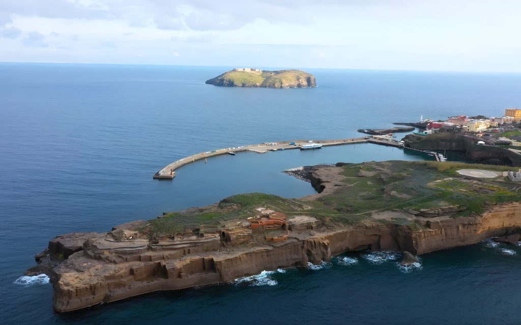
Ventotene and Santo Stefano Islands (Italy) were recently voted the historical capital of European morals and intellect as it also hosts the monumental Panopticon prison inspired by an “ideal” design of reclusion and effectively transformed in a symbol of repression of ideals of freedom. The archaeological site of Villa di Giulia, located at Capo Eolo, in correspondence with a stretch of coast facing west in the northern sector of the island of Ventotene, was a “golden prison” for high-ranking Roman women, among which the daughter of August and the mother of Nero. The Island of Ventotene is of volcanic origin and constitutes the wreck of an ancient caldera of which only the islands of Ventotene and Santo Stefano, are witnesses today. The geological nature of the rocky outcrops in Ventotene and Santo Stefano predisposes them to intense alteration connected to meteorological forcings and marine erosion that occurs intensely along the sea cliffs. This causes extensive and visible landslides which manifests themselves in the form of blocks delimited by a steep coastal wall and delimited upstream by open fractures.
Use case of TRIQUETRA technologies
The case study represents an archaeological typology extended adjacent to coastal sea slopes, subject to phenomena of gravitational instability due to landslides of entire cliff portions. This criticality is strictly connected to weather-climatic conditions of the coastal site as well as to dynamics of the sea both in tremors of seasonal episodicity (storms) and climatic variations (primarily SLR). The possibility of applying geophysical and weather-environmental monitoring techniques allow to zonate the degree of hazard in the coastal section of the archaeological site, thus making it possible to evaluate the severity of reliable collapse scenarios due to landslides as well as directing towards a differentiated assessment of intents and defence systems of the property exposed along the coast. The consortium will apply passive seismic geophysics techniques aimed at identifying, through micro-seismicity and modifications in the vibrational behaviour of isolated blocks of rock, any drifts towards phases of increasing instability and / or paroxysm. However, for a correct interpretation of these data, prolonged weather-climatic and environmental monitoring will be necessary in order to measure the intensity of destabilizing factors such as wind, sea waves, air and rock temperatures. High resolution 3D photogrammetric models, ad hoc products, will support the analysis and return phases of the monitoring data acquired during the measurement campaigns. The methods of integrated geophysics that provide for the measurement of environmental seismic vibrations in unstable areas together with the monitoring of environmental parameters (such as temperature, wind, sea waves) rarely show variations in the mechanical behaviour of potentially unstable rock masses which constitute any precursor evidence to paroxysmal phenomena of collapse. Before the occurrence of a gravitational collapse, the rocky system first begins to behave differently (i.e. oscillating more freely and intensely) and, often in the imminence of collapse, it emits microseisms connected to neo-fracturing and/or detachments of insignificant size rock portions, thus anticipating the real phase of generalised collapse. Identifying blocks with vibrational behaviour characterised by greater degrees of freedom indicates advanced process of separation of the rock from the rest of the mass and therefore of greater severity than the expected paroxysmal course. This allows the selective choice of solutions and the scheduling of a schedule of consolidation / safety interventions more in keeping with the severity of the geological hazard.
Preparatory activities and work to be done within TRIQUETRA
The research activities involve a collection of existing geological and meteorological-climatic data as well as detailed documentation relating to the archaeological site, its most recent installations and / or restoration or consolidation plans, followed by geological-technical survey activities and the archaeological essays. Lastly, the geophysical campaigns will be conducted on a multi-seasonal basis, each with a multi-hourly and / or multi-day duration depending on the technical specifications applied. A geological hazard severity assessment will be performed, allowing to design a supervisory monitoring system for the authorities managing the site. Every decision regarding conservation will be made taking into account existing information, in collaboration with the archaeological superintendency, fellow geologists, landscape architects and restorers. Monitoring will be substantially terrestrial, consisting of local installations continuously detecting geophysical & meteo-climatic data, sent to a management and control centre located at the local management authorities of VENTOTENE.
Past work and issues faced by the site
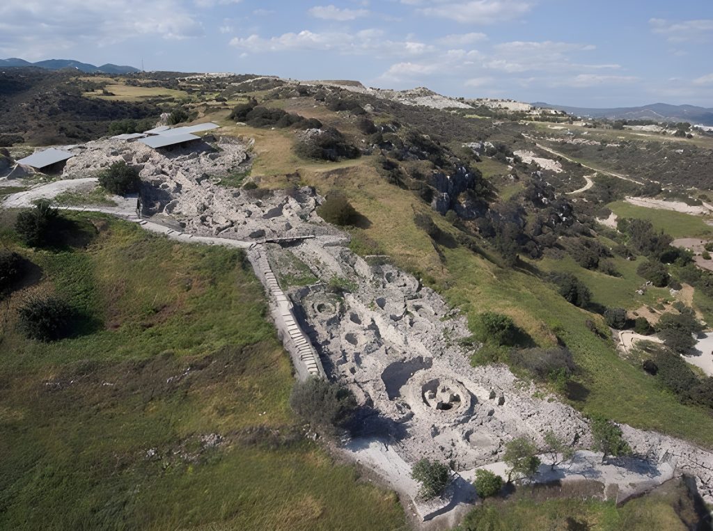
Since the 1970s, the site underwent several attempts of restoration and consolidation. The walls of the inner suburb were restored and consolidated mostly in the course of the excavations in the 1970s and 1980s, but the outer suburbs and the western area were hardly safeguarded until 2015. Due to the long excavation since the end of the 19th century, many prehistoric to archaic walls in the Outer suburb were exposed for decades, leading to underwashing of walls and foundations. The deep excavation cuts with high upcoming walls were problematic for the stability of the walls. The suburbs were subject of a new, extensive restoration campaign that started in 2011 with scientific analysis under the director K. Sporn and the architect A. Tanner (Zurich). Since 2015, the extensive restoration program focused on backfilling and on consolidating the walls with different, scientifically approved mortars. A special problem is the western area of Kolonna, which is occupied by a sacred site, overbuilt by Byzantine cisterns and houses. This area wa s excavated in the early 2000s and partially backfilled. This area is exposed to winter storms and constant waves produced by the heavy traffic between Aegina and Athens (a commercial ferry boat every half hour; heavy private traffic). Every year, the archaeological zone deteriorates, especially in the west, due to ruptures in the soil (fig. above). The problem is currently not solved because of the danger of collapse.
Use case of TRIQUETRA technologies
Measurements to detect the geological hazard related to ground instabilities and to protect the cliffs from waves and precipitation. Specific geophysical campaigns will be carried out in the site.
Preparatory activities and work to be done within TRIQUETRA
The work plan foresees a thorough analysis of the reasons of the growing demolition of the site. It is crucial to understand the difference between natural waves, waves produced by ship traffic, and the changes of current behaviour. It will also be important to include climate studies in order to understand changes of precipitation over the past decades. Methodologically, analysis of archival images, satellite and infra-red images will be needed in addition to chemical and physical study of the endangered cliffs. This will lead to first risk identification, and, second, to risk quantification In a third step, methods – proved and those being developed in TRIQUETRA – will be applied in order to minimise risks and develop strategies to prevent the cliffs from damage.
Past work and issues faced by the site
Monitoring natural hazards due to CC of CH sites facilitate the early recognition of potential risks and enables effective conservation monitoring and planning. Landslides, earthquakes, rock falls, ground subsidence and erosion are the predominant natural hazards in Cyprus, which pose serious disadvantages to CH sites as well as potential danger to tourists. To identify and monitor natural hazards and environmental displacements due to CC, Earth observation techniques, such as SAR, can be used in combination with long‐term low‐impact monitoring systems, such as UAVs and geodetic techniques by using permanent GNSS stations and corner reflectors and analysing multitemporal SAR satellite data to estimate the rate of land movement. A recurring theme of studies on natural hazards affecting CH sites is the need to strengthen monitoring and maintenance of vulnerable CH sites. Research indicates that the integration of satellite data and in‐situ data offers the best solution for monitoring natural hazards in CH sites.
Use case of TRIQUETRA technologies
The Choirokoitia site will examine the potential risk of rockfall, as the topology of the site is vulnerable to movements as a result of extreme climate change as well as of daily/seasonal stressing actions, i.e. related to the thermal cycles. Specific geophysical campaigns will be carried out in the site. This may pose a danger to tourist safety as well as damage to the CH site.
Preparatory activities and work to be done within TRIQUETRA
Data from a permanent GNSS station and corner reflector will be collected, as well as analysing multitemporal SAR satellite data in order to estimate the rate of land movement. Rockfall modelling will also be simulated using 3D modelling from UAV photogrammetry. The project team members will be in close cooperation with the Department of Antiquities. Within the project, the case study will be used to detect and analyse natural hazards induced ground deformation based on InSAR ground motion data and field survey techniques for CH applications. InSAR data, satellite positioning and conventional surveying techniques will be employed to measure micro-movements, while other techniques such as UAVs and photogrammetry will be used for documentation purposes and 3D modelling comparisons. In order to identify and monitor natural hazards and their severity, a permanent GNSS station and corner reflector, as well as analysing multitemporal SAR satellite data will be used to estimate the rate of land movement. SAR monitoring provides the opportunity to identify deformation phenomena resulting from natural hazards for monitoring and assessing potential hazards using remote sensing techniques to measure and document the damage on the CH site. The methodology to be used for the local scale monitoring begins with the use of InSAR images to identify natural hazards in the Choirokoitia site. When InSAR ground motion data indicates that a natural hazard is evident at or near the CH site, field monitoring and verification will be used to document and measure the extent of change caused by natural and/or geo-hazards, if any. PSI (Persistent Scatterer Interferometry) analysis can be used in the wider area to determine potential displacements.

Past work and issues faced by the site
Bio-erosion is one of the most obvious risks faced by these underwater and coastal archaeological findings. The Sunken City and the coastal CH findings are slowly being eroded by the presence of water and microorganisms. The danger due to sea level rise is threatening the coastal archaeological findings, while coastal erosion is yet another threat. Flood phenomena on the coastal land with deposits of sediments in the sea and embankments near the coastal area for construction projects of ports comprise additional hazards. Also, damage is caused by illegal mooring of tourist boats. Finally, exposure to chemicals, consequences of possible earthquake in the area and possibly vandalism are real threats to this site. Systematic conservation and promotion works have already begun, with a parallel excavation in the entire area.
Use case of TRIQUETRA technologies
The 3D modelling of CH sites and especially underwater antiquities is a challenging process, since the particularities and the detail presented by both the object and the aquatic environment make this process special, difficult and quite complex. The detailed 3D survey of the underwater and coastal CH resources of Ancient Epidaurus, the literature review, the concentration of archaeological studies of the area and the related data that will form the knowledge basis of the TRIQUETRA DSS will considerably lead to (i) the prevention of any deterioration of the CH site caused by overtourism and natural and man-made hazards, (ii) its organized protection, (iii) the preparation of the best solution concerning plans and suggestions for sustainable tourism development in the area as well as suggestions for restoration of the site.
Preparatory activities and work to be done within TRIQUETRA
New data collection techniques from the fields of surveying, photogrammetry and remote sensing will be implemented for data capturing, after contact with local stakeholders. The project team members will be in close cooperation with the local municipality, the Archaeological Service of the area, the Marine Antiquities Service, guides and travel agents. High accuracy photorealistic 3D models of the coastal and underwater antiquities will be captured using modern techniques. A combination of aerial and closerange photogrammetry, terrestrial laser scanners and aerial LiDAR sensors will be used for the coastal part of Ancient Epidaurus and hydrographic multi-beam sonar surveys and underwater photogrammetry will be used for the underwater part of the site. A common reference network for all reality capturing surveys will be established and all the intermediate steps of the process will be assessed for their accuracy. New techniques will be established for being used for future monitoring of CH sites and for creating a platform for interdisciplinary cooperation. Furthermore, this work will focus on the process of detection and monitoring of changes, damage, or deterioration. One of the most important aspects that will be addressed is a systematic approach that catches changes at an early stage, so that interventions can be conducted or appropriate action can be taken. Finally, all the data of the survey will be uploaded for further processing and collaboration on TRIQUETRA’s online platform. The high-accuracy 3D detailed survey of Epidaurus antiquities and their neighbouring area will be used by the rest of the team members for their part of the scientific research and also as a reference frame for all outcomes of the project.
Digital Twin
The Digital Twin of the CH site of Ancient Epidaurus will be generated, constituting a virtual environment for the consolidation and dissemination of CH information of the area and the basis for the decision-making process regarding risk identification, quantification and mitigation. It will also form the basis for other kind of applications, like augmented reality (AR) and virtual reality (VR) apps. Risk data will be stored, processed, and associated with the virtual product within the TRIQUETRA platform, allowing awareness of physical space and simulation in virtual space for decision making on how to prevent disasters and mitigate risks due to natural and man-made hazards. The potential application of the digital twin for the site of Epidaurus is its realistic representation in the form of a semantically enriched 3D model, becoming a tool capable of aiding decision making for protection and possible restoration of the CH site.
[/expander_maker]
Past work and issues faced by the site
As a first step towards systematic monitoring of the site, BLFD established a measuring system that serves as the basis for systematic observation of the site. A total of 174 measuring posts were positioned into the shallow water zone around Roseninsel. The oak posts function also as erosion markers and are checked annually. In addition to that, the extension of macrophytes has been documented over the last years. The programme produced evidence for a substantial reorganisation of the shore-zone of the island in the early medieval period, which is dendrochro nologically dated to the years around 700 AD.
Use case of TRIQUETRA technologies
DLR’s newly developed robotic surface vehicle LimnoVIS will be used to derive highly resolved and accurately georeferenced bathymetry maps and orthophotos of the submerged structures and the lake floor. LiDAR measurements will complement this dataset, and the comparison of the results from the two independent methods will allow quantifying the accuracy of the derived products. This dataset will not only serve to document the status quo of site, it will also help to optimize the algorithms for processing the data from spatially highly resolved multispectral satellites and to create bathymetry maps of larger areas around the Roseninsel. The validated algorithms and the integration of satellite data into a GIS allow for easy change detection when ever necessary, e.g. to detect erosion processes after heavy weather events. Satellite data with lower spatial resolution but higher spectral information (e.g. Sentinel-2, DESIS, EnMAP) will be used to monitor water quality parameters related to turbidity and eutrophication that help to assess the impact of ongoing natural and anthropogenic processes.
Preparatory activities and work to be done within TRIQUETRA
In summer 2022 measurements will be carried out within the research programme SuBoLakes, to better understand the impact of waves created by regular service ships as well as private boats on the shallow water zone and coastal line of Roseninsel. Satellite-derived bathymetry maps as well as high-resolution bathymetry maps through in situ measurements carried out with green laser and sonar-based systems will provide valuable information for the Heritage Risk Assessment. In addition to that, the risk assessment can draw on data collected in the course of the World Heritage monitoring programme carried out by BLFD since 2014. Further assessments will evaluate factors such as impact of snow/ice, wave erosion, biological and chemical hazards connected with water quality, and atmospheric hazards, in order to understand their relevance for the conservation of the archaeological monument in the context of CC and human activities.
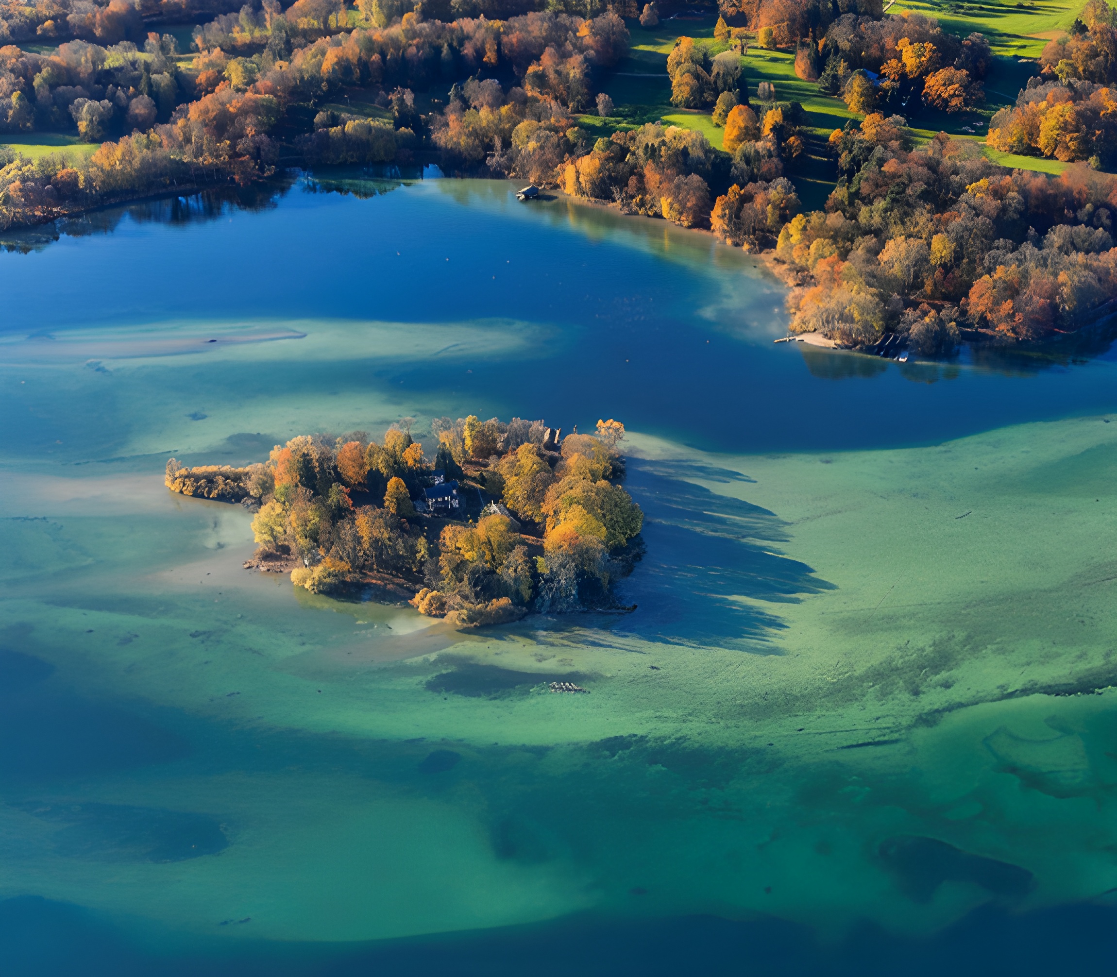
Past work and issues faced by the site
Argiliez is a protected site, forbidden to navigation and marked by yellow buoys. In 2014, a topographic survey identified 4,834 piles. Two zones can be distinguished: to the west, the piles are barely perceptible, very tightly packed and protected by a dense accumulation of pebbles; whereas to the east, they are apparent, sometimes up to nearly 50 cm high, and scattered in the lacustrine chalk. Off the site, to the east and west, an erosion front is active and progressively cuts into the site. It comes from a notable difference in depth between the centre of the site and the periphery, which allows lake currents to progressively erode the deposit from the periphery. The currents in the lake are very dynamic and their intensity can change from year to year. Regular 3D modelling of the erosion front is essential to monitor the evolution of the erosion and allow proper preservation measures. The above-ground height of the piles of a village is also an indicator of the evolution of erosion. The more the piles protrude from the sediment, the more intense the erosion. Photogrammetry is carried out on control areas, but it would be important to be able to document the entire site and to have a 3D tool to accurately evaluate the height above ground of the piles. Global warming with a decrease in precipitation has resulted in a lower average lake level, which has accentuated the erosive phenomenon. The water quality has also been changing for several years. A proliferation of lake mussels is visible in the western half of the lake and is moving eastward, affecting the Argilliez station. These mussels contribute to degradation of archaeological furniture (particularly organic matter).
Use case of TRIQUETRA technologies
As described above, a tool for regular inspections and monitoring of the erosion on the Argilliez station is identified. The generation of geo-referenced 3D data with the unique bathymetric LiDAR prototype will allow validating the concept for cultural sites preservation. A flash imaging LiDAR generates 3D images of the target in a single snapshot, which confers the following advantages over a traditional scanning architecture: better integration (i.e. miniaturisation), longer lifetime (i.e. no mechanical fatigue), no compromise on angular resolution, measurement rate or platform stability (i.e. limited motion blur). Thanks to a centimetric resolution in 3D, the height above the ground of each pile will be monitored over regular campaigns, enabling to measure the erosion process over time. Inherent to data obtained during airborne measurements, the water depth will also be retrieved. Moreover, based on advanced image processing and combination with camera images, the quantification and evolution of mussels may be surveyed.
Preparatory activities and work to be done within TRIQUETRA
A precise plan of the site will be made with the topography carried out in 2014, identifying erosion areas. By integrating a flash LiDAR on different unmanned vehicles, both surface (USV) and aerial (UAV), we will carry out regular measurement campaigns over 6 months. External suppliers of UAV flight service will be used. For the first campaign, the site will be surveyed with both vehicles. This will allow to assess data quality and processing possibilities, for each platform. Due to its low height, the USV limits surface coverage by each image, hindering the mosaicking process, but benefits from a high stability in calm water and longer autonomy than UAVs. On the other hand, imaging from a UAV facilitates the mosaicking process, at the expense of image distortion compensation due to wavelets on the water surface. The best-suited vehicles will be selected for further campaigns. Depending on the results, both vehicles may be used for the next surveys. After a calibration and evaluation of acquired data in terms of precision, a 3D map of the site will be created. This will be compared against existing data to validate the approach. After validation, it will be used as basis for follow-up measurement campaigns performed over the course of the project (4 to 5 surveys planned in total).
Past work and issues faced by the site
Noninvasive investigations (geophysical survey and air photo interpretation) undertaken in 2007 and 2008 showed a very clear plan of structures (wooden buildings, paved wooden streets, hearths etc.). Only a few such settlements have been recorded and all of them are threatened by climate changes and related anthropogenic activities. Fluctuating water level affects the wooden structures of the fortified settlement and other organic materials both within and around the settlement. The decrease in precipitation transforms farming practices, in particular attempts to retain water in the fields surrounding the valley and lakes. This further aggravates the lowering of the water level in the reservoirs. On the other hand, sporadic, intense rainfall causes rapid water runoff and short-term flooding. Frequent changes in the water level have a significant negative impact on archaeological remains (especially organic ones). Changing agricultural practices in the surrounding fields, in particular intensive use of fertilizers, also have an impact on changing the chemistry of water in reservoirs, leading to an algal bloom As a result of CC, the water temperature also changes, and this causes further transformations of in flora and fauna in water reservoirs and their direct vicinity.
Use case of TRIQUETRA technologies
The project will propose an integrated methodological model to monitor changing local conditions and their impact on very sensitive (organic) archaeological remains. Remote sensing data (mostly satellite imagery) and environmental data integrated within GIS will allow a continuous real-time monitoring of the site and the impact of ongoing natural and anthropogenic processes. The possibility of testing methods and verify solutions is important in the context of applying them also to the other archaeological sites in the future.
Preparatory activities and work to be done within TRIQUETRA
Data available to be collected include historic meteorological data, soil maps, flora and fauna data, ALS data, historic and modern aerial photographs (oblique and vertical), historic cartography, and information on archaeological activities. The project has regional heritage officer’s permission for application non-invasive methods (underwater survey, geophysical methods) and will secure owner permission for undertaking investigation in the field. Mapping existing information and combining with data acquired during the project (UAV aerial survey, VHR satellite imagery, geophysics) within GIS will provide better knowledge about the ongoing natural and anthropogenic processes (risk measurements). Multi-temporal and multifaceted information will facilitate decision-making authorities and local societies to protect the site (risk mitigation). The acquired RS and environmental data integrated within GIS as well as understanding ongoing processes will allow building strategies for protection and management of the site (as representative for other similar in the region) at two levels – governmental and local.
Digital Twin
General activities of the project will be carried out in Smuszewo in the cooperation with local society and will be open to the public. AMU together with NID will co-organize workshops for local community to further promote the project events. The endusers and the local communities related to the study case site will be informed and engaged during the field campaigns and workshops as well as consulted in building strategies for future