Skip to content

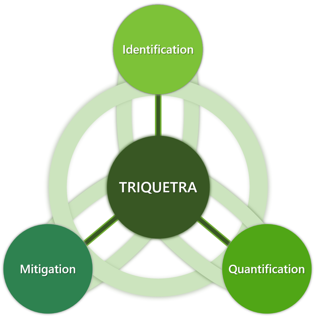
LEARN ABOUT TRIQUETRA
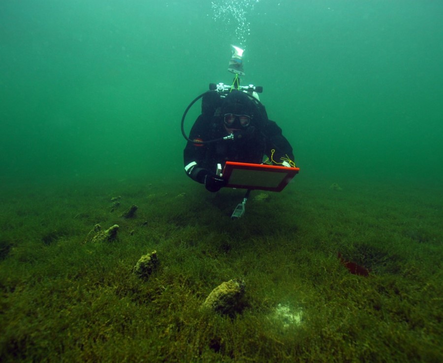

ABOUT THE PROJECT

The TRIQUETRA project aims at creating an evidence-based assessment platform that allows precise risk stratification, and also creates a database of available mitigation measures and strategies, acting as a Decision Support Tool towards efficient risk mitigation and site remediation.

The overall approach of Triquetra is based on three distinct steps:
1. Risk Identification
2. Risk Quantification
3. Risk Mitigation

This “trifecta” approach (hence the name Triquetra) creates a framework of risk assessment and risk mitigation so as to tackle as many of these risks as possible, in the most efficient way available.

A total of 21 organizations from 7 countries participate in the project, including 8 Universities and Research Organizations and 6 Cultural Heritage Authorities. The project started on 01/01/2023 and will last for 3 years. TRIQUETRA project is funded from the EU HE research and innovation programme under GA No. 101094818.

Addresed Cultural Heritage Typologies

Mainland – rural areas are less likely to be shielded in remote areas with scarce population and lack of surrounding infrastructure.

Underwater sites are increasingly affected by climate change (e.g. changes in the chemical composition of oceans).

Coastal areas shall be a focus for the approach to validate its various water-protection and water-related damage detecting techniques.

Novel Tools for In-situ Sensing & Monitoring

TRIQUETRA’s data collection will provide an insight to all the variables directly or indirectly connected to CC, comparing them with historical data. New innovative surveying techniques are utilized: Hydrographic surveys, multi-beam sonars, UAVs with optical, multispectral & LiDAR sensors, underwater photogrammetry, laser spectroscopy, novel simulation models and more.

Flash imaging LiDAR
Despite a clear potential of the flash LiDAR for geo-referenced underwater 3D mapping, further developments will be tackled during the project to full demonstrate the applicability to CH site surveys. Emphasis will be put on hardware implementation and data processing to generate depth maps (3D images) over a large area through the mosaicking (or stitching) of single images obtained within a relatively limited field-of-view (FOV) campaigns.

SWARM sensor – pH, temperature, turbidity, ions & O2 in-situ monitoring
The SWARM system will be used to monitor turbidity with main goal to improve 3D mapping of shallow water with novel flash imaging LiDAR technology. It will provide meaningful data in optimising LiDAR data.

Laser-based spectroscopic sensor for in-situ real-time water quality analysis
Infrared (IR) spectroscopy is among the main laboratory tools to detect, measure and characterize organic material such as hydrocarbons and a plethora of compounds that exhibit strong fingerprint signature in the mid-IR spectrum. Such analysers are used in laboratories and can be implemented as tools in the field.
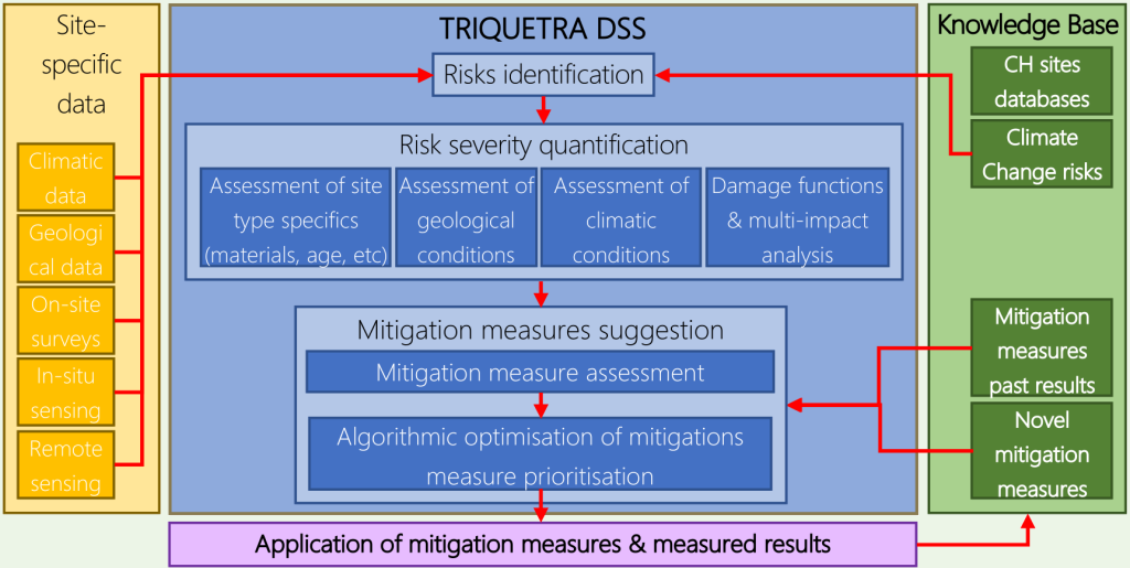
Read more

Decision Support Platform

By integrating all the modules and technologies in TRIQUETRA, a DSS will be developed and validated in actual working conditions in 8 different pilot sites across Europe, spanning a wide range of archaeological periods, CH typology, structures and materials.

The TRIQUETRA DSS
In TRIQUETRA, we will develop a DSS that will enable stakeholders and decision makers to make the most educated decisions related to risk mitigation and remediation of endangered CH sites. In addition, TRIQUETRA will develop a set of novel nanotechnology based coatings for preserving CH sites, without compromising their authenticity. TRIQUETRA will put together a Knowledge Base platform, comprising all existing methods and techniques for remediating such CH sites, while also developing novel CH protection technologies, going beyond state of the art

Read more